Although Sydney started to flood this week, weather experts say that we may receive a short-lived reprieve from the torrential downpour. Just in time for Mardi Gras too, thank gay Jesus.
Sydney’s main water source the Warragamba Dam overflowed on Wednesday morning and since then, suburbs have noticed a significant amount of rising water. The Bureau of Meteorology (BoM) has predicted the Warragamba Dam could stay at or above full capacity for approximately two weeks.
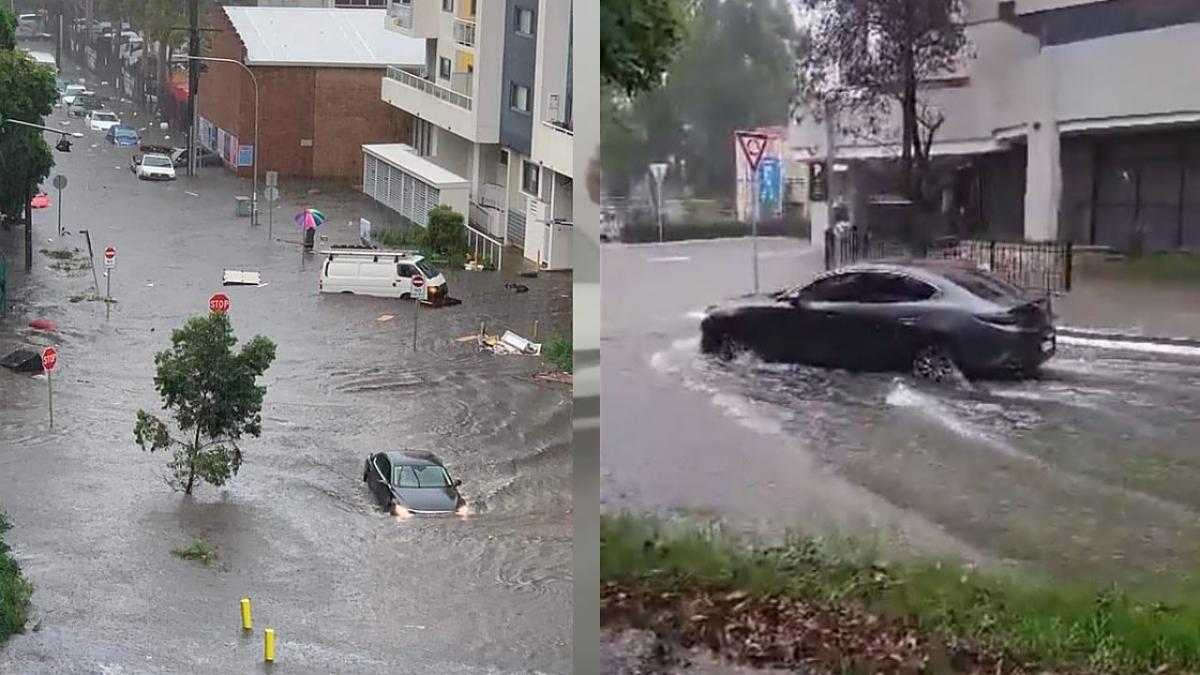
The storms that originally wreaked havoc in southeast Queensland are now moving through Sydney and towards Melbourne, though experts say they’ll be back in Sydney soon enough. Some girls just can’t get enough of ol’ Sydvegas.
Penrith, Parramatta, Picton and Marrickville specifically were reported to have started to flood and more than 500,000 individuals were told to evacuate as apocalyptic rain lashed parts of NSW.
Multiple evacuation orders across the state have been lifted, with the worst of the NSW flooding predicted to have hit on Thursday night. However, severe thunderstorm warnings are still out for the mid-north coast and the Hunter region.
New evacuation orders are out for those living near the Cumberland Reach, Hawkesbury River and Gloucester River.
⚠️⛈️Severe Thunderstorm Warning: For heavy rainfall that may lead to flash flooding in the #Hunter and #MidNorthCoast. Locations which may be affected include #Forster, #SealRocks, #Bulahdelah, #Wingham, #NelsonBay and #Dungog. Full warning details https://t.co/Ss766eSCrL pic.twitter.com/GtPs7hRnL5
— Bureau of Meteorology, New South Wales (@BOM_NSW) March 3, 2022
Western sydney 2171 , not even one of the areas properly affected by the floods , stay safe out there guys pic.twitter.com/rsOLaL60uL
— shelton (@SHELTONZOR) March 2, 2022
This is the line #nswgov has been giving us all to justify building a museum on this site in Parramatta. All locals know it floods but they assure us only 1/1000 year flood will be an issue to the $915m project. pic.twitter.com/T4mfVatV5X
— Suzette McCrea (@queenmcmeade) March 2, 2022
Helpful video shows how Sydney’s Warragamba dam works during floods – Daily Mail https://t.co/MYuAQexyHm #damnews #dam pic.twitter.com/OMGiD9TEdV
— Dam News (@damnews_en) March 2, 2022
#BREAKING The current situation on Woodriff St in Penrith near the Astina building and Judges Car Park. pic.twitter.com/pRQQMu8W4v
— Western Weekender (@wwpenrith) March 2, 2022
“Flash flooding is definitely on the cards, through Sydney down to about Bega,” said BoM Meteorologist Jackson Brown earlier this week.
“We have flood warnings from the Hunter right down towards the Victorian border.
“As well as that, with all that easterly moisture pouring in, it’s whipped up the waves so we have abnormal tides and we’re looking at quite a bit of coastal erosion along some of the places south of Newcastle.”
You’ve probably come across a multitude of horrifying images from the Queensland and northern NSW floods, including imagery of many a displaced item or cow.
At the time of publication, there were at least 10 confirmed deaths from the floods, including one Emergency Service worker who died while trying to rescue a family in Coolana. Hundreds of people remain unaccounted for.
More than 1,000 residents across NSW have been rescued so far.
If you don’t know about Lismore Maccas height. This is unfathomable, what on earth pic.twitter.com/q5wKUqNgcF
— Jackson (@Jaksuhhn) February 28, 2022
A cow on a roof in Lismore @9NewsAUS pic.twitter.com/owF8RHO7qH
— Sophie Walsh (@sophie_walsh9) March 1, 2022
Wild gusts of 125km/h are predicted for Sydney this week, and severe thunderstorms and heavy rainfall are still predicted to appear over multiple regions.
Sydney received a total of 200mm of rain over Tuesday and Wednesday — the worst days so far — while the rest of the week saw a less intense rainfall.
Kiama and Batemans Bay reportedly received 230mm over the two days.
A number of forecast models suggest that a low pressure system could deepen over the Tasman Sea from Tuesday and approach the central NSW coast on Wednesday. This will be a system to watch in the coming days as it could bring more severe weather in eastern Australia. pic.twitter.com/5KRkwCDlRv
— Ben Domensino (@Ben_Domensino) February 28, 2022
In Lismore we have done floods for ever. This is not a flood – this is catastrophic. This is extreme. This is climate change. Lismore needs back up. People are on and in their roof some are screaming for their lives and water is still rising. Friends are rescuing friends. pic.twitter.com/NwikdHTX0V
— Sue Higginson (@SueHigginson_) February 27, 2022
“There will be storms. There will be trees down. There will be roof damage. There will be power breakages,” NSW State Emergency Services (SES) Commissioner Carlene York told Nine.
“But I ask the community to be patient, because we will be doing rescue operations first and prioritising that over property damage.
“We’re working closely with the bureau in relation to our preparations for the Central Coast, the metropolitan area, the South Coast and into the mountain ranges as well towards the Southern Highlands and southern district.”
The wild weather has well and truly arrived in Sydney. Here’s the view from our weather cam. pic.twitter.com/IiYwI5CdrW
— Sunrise (@sunriseon7) February 28, 2022
https://twitter.com/kailaswild/status/1498051811055652868?s=20&t=A3ZTPDwWKOZwRJ9cexalAA
Actual photo of the Australian Prime Minister helping out in the Brisbane Floods pic.twitter.com/ArLKsUqt8y
— Kitchener Leslie (@mckenney_caleb) February 26, 2022
Stay safe out there friends.


