Wild weather has absolutely ravaged most New South Wales and Victoria over the last 24 hours, and brace yourselves because it’s not about to calm down anytime soon.
According to the Bureau of Meteorology, “Antarctic” winds of up to 90km/hr have been predicted for areas of NSW including the Snowy Mountains and the south coast.
[jwplayer m9qKjnWy]
The strong winds and cold front aren’t expected to clear until early on Monday morning, so it looks like you’d better grab your hot water bottle and get ready for a Netflix binge because it’s definitely not clubbing weather this weekend!
“Cool conditions really stay with us through the weekend though they will ease off by mid next week – but it will take a little while to get there,” Bureau of Meteorology duty forecaster Keris Arndt said.
There have been more than 900 requests for help from the NSW SES since Thursday morning, according to The Guardian, with more than 350 of them in Sydney alone. An additional 700 calls were made in Victoria on Friday.
To give you a sense of how thick the snow is in the Blue Mountains. #snow pic.twitter.com/ju9KmAjSDt
— Erin Turner (@ErinLTurner) August 9, 2019
Something feels out of place. #ausweather pic.twitter.com/r8sps8o1oE
— Dr. Alex Wallace (@AlexLWallace) August 10, 2019
The Blue Mountains are turning white ❄️ #bluemountainsnsw #visitnsw pic.twitter.com/aNvUcsXmMr
— Hayden Quinn (@hayden_quinn) August 9, 2019
Winds are expected to ease off to about 60-70km/hr tonight, but we’re going to be in for a wet one with up to 40mm of rainfall expected today.
“No doubt it will feel much colder because of the wind chill,” Keris Arndt said.
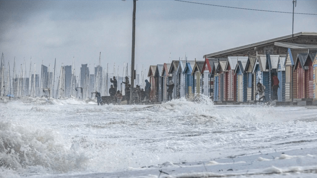
This storm could be the worst case of extreme winter weather to ravage the country in years, with damage appearing all over the country. We’ve seen the Frankston Pier wash away in Victoria, roofs ripped off buildings and even snow at the bloody AFL, and the crazy weather isn’t even close to being over.
However, the crazy weather did give a few unsuspecting locals a snowy Saturday morning, with snowfall being reported as low as 500m above sea level in the Dandenong Ranges and Central Highlands. Residents of Cootamundra and Riverina claim it’s the first time they’ve seen snowfall in the towns in decades.
Can’t decide outside if it wants to #snow or rain, or do something in between but it’s all blowing horizontal. Here’s some plant photos taken earlier. Silver-leaved mountain gum, Silver Banksia, Royal Grevillea and the lone Orange Tree. #snowyvalleys #riverina pic.twitter.com/yXFAMT7XvJ
— Bindi Vanzella 🇺🇦 🇮🇹 (@bidgeewidgee) August 10, 2019
“We’ll see temperatures really plummet and snow levels down to 500m in Victoria and NSW and blizzard conditions in Alpine areas. It certainly is a real cold snap, now is the time to prepare,” the Bureau of Meteorology’s Michael Logan said.
But there’s some good news for travellers, as the cold, wet weather isn’t expected to cause delays or cancellations at the airport. This is a huge relief after the chaos at both Sydney and Melbourne Airports yesterday.
Severe weather warnings for damaging winds are still in place for most of the NSW coast, as well as Victoria’s south west region and East Gippsland. So it looks like it’s time to rug up in bed and binge watch weird docos on Netflix all weekend.