
Hey Victorians!
We’re sorry if you’re sick of us saying this by now, but HOOOO BOY are you in for some weather today. Some weather indeed, yessiree.
The Bureau of Meteorology is reporting that you lot are gonna be thrashed by hectic high speed winds mainly today, but it’s gonna continue on for a few days and will be paired with a lovely side of rain and snow on Tues/Wed!
It got up to an insane 100km/h in areas such as Mt Buller, and in metropolitans it was hitting marks of 50-60km/h.
So, wild and woolly – just the way Melburnians like it, yeah?
Will it snow at your place Tuesday? Icy blast coming, snow down to 300m #snow #vicweather https://t.co/zdLTMNeQmT pic.twitter.com/gpjHXIvMCE
— BOM Victoria (@BOM_Vic) July 10, 2016
BOM senior forecaster Rod Dickson said,
“Maximum gusts overnight were around the 100 km/h mark at places like Kilmore and Mt Buller but most winds gusts in the metropolitan area overnight were around the 50/60 km/h.We are likely to see thunderstorms develop from the west on Tuesday and a very cold air mass so some small hail is likely with the showers as well from Tuesday through to Wednesday afternoon.There will be some pretty chilly mornings after that, close to zero over a large part of inland Victoria later in the week but maximum temperatures will return to mid-teens.”
100 km/h wind gust at Mt William. Severe Weather Warning for damaging winds for today and tomorrow #vicweather https://t.co/HLs2UYFQyQ
— BOM Victoria (@BOM_Vic) July 10, 2016
Today’s looking like 15 degrees, then it’ll drop to 12 tomorrow, and down to 11 on Wednesday. BRRRRRRRR.
Here’s the low whipping up winds across #Victoria today. Rain coming too. Check the warning https://t.co/HLs2UYFQyQ pic.twitter.com/xipqyWGX5H
— BOM Victoria (@BOM_Vic) July 9, 2016
SES spokespeople have said they’ve received reports of trees being blown into houses, but no major damage as of yet.
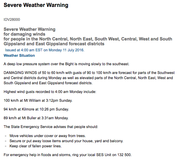
Here’s the current warning for areas of VIC:
Stay safe this week Melbourne; winter is nearly halfway donezo.