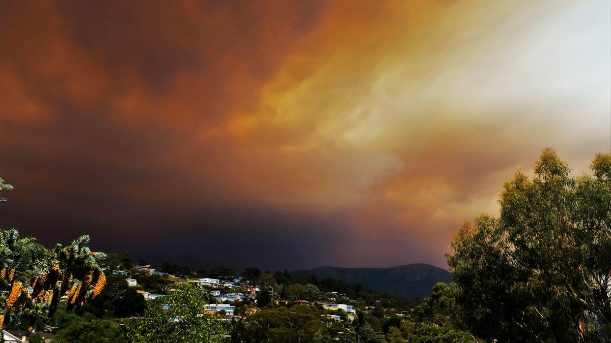
It’s a very spoopy time on the Apple Isle this afternoon. A bushfire burning in Gell River in Tasmania‘s southwest has blanketed the south of the state in thick smoke, which has had the effect of making everything look a helluva lot like the end of the world.
The fire has been whipped up by very hot, dry and windy conditions, making it hard for local fireys to get under control. Fortunately, at the moment it’s burning some distance from any people or property, but locals in Maydena, Tyenna, National Park township, Mt Field, Bushy Park, Ellendale, Westerway and Fentonbury – all northwest of Hobart – have been issued a Watch & Act warning.
https://t.co/0RJ2KQZyqC #BREAKING: A watch and act is issued for the Tasmanian towns of Maydena and Tyenna, west of Hobart, as a wilderness fire sends a smoke cloud over the state’s capital.
— ABC Hobart (@abchobart) January 4, 2019
The fire has spread across 10,000 hectares but is too out of control for @TasFireService to extinguish unless there’s a significant weather change
— ABC Hobart (@abchobart) January 4, 2019
Evacuated from Mt Field National Park. Lots of smoke and ash! @abchobart pic.twitter.com/5tM86LmPdS
— Katie Tunks Leach (@KatieTunksLeach) January 4, 2019
For everyone else, it’s been a spectacular – and ominous – show. Several planes have been grounded at Hobart Airport, with some incoming flights diverted to Launceston, and a very crowded terminal as people wait for their delayed flights.
@VirginAustralia flight to Melb cancelled and some @JetstarAirways flights diverted to Launny due to smoke and crosswinds. Airport is very crowded @abchobart @themercurycomau @tasnightlynews #hobart #tasmania #tasnews pic.twitter.com/klFDaWp8O1
— Mathew Sharp (@mathewasharp) January 4, 2019
Very eerie over Stewarts Bay on the Tasman Peninsula @abchobart pic.twitter.com/p6Zo5F0OLP
— Monte Bovill (@MonteBovill) January 4, 2019
Smoke rolling in over Mt Wellington, seen from New Town. #hobart pic.twitter.com/lk5EmPGiNZ
— David Reilly (@EventualAnimal) January 4, 2019
Stark contrast over #Hobart right now as the smoke blows over #Tasmania pic.twitter.com/21OJdqD4Va
— Dominic Anastasio (@domin8tor_1) January 4, 2019
Impact of bushfire burning in Tas’ wilderness world heritage area near Mt Field and Franklin-Gordon Wild Rivers National Parks ~100 km’s away from #Hobart. pic.twitter.com/VCGwGXwCFY
— Peta Heffernan (@petaheffernan) January 4, 2019
Unreal image of the Cascade Brewery! #Tasmania #hobart #bushfire #hot #summer pic.twitter.com/cd5qY3BxDU
— Max Möller (@Max_W_Moller) January 4, 2019
#Hobart, what the heck?¿ pic.twitter.com/1VRhyOEBug
— Sharifah Zaliah (@SharifahZaliah) January 4, 2019
And another from Hinsby Beach a friend sent me, looks very apocalyptic @abchobart @abcnews (by Paul Seymour) pic.twitter.com/1NUrOmDCrR
— Georgie Burgess (@GeorgieJBurgess) January 4, 2019
People leaving Maydena and Westerway as more ash falls from the Gell River fire. People worried about the homes they’ve left behind, as well as their chickens and alpacas. @abchobart pic.twitter.com/kYQhnK9Dcx
— Ellen Coulter (@ellencoulter) January 4, 2019
The eeriest pictures come courtesy of the Bureau of Meteorology‘s satellite feed, which show smoke from the fire in a streaming plume blowing southeast.
https://twitter.com/TasProspector/status/1081023826106900480
Satellite pic clearly showing the smoke plume over Hobart and surrounds from the fire in the southwest.
See for yourself at: https://t.co/sE8cPnCNXP pic.twitter.com/rIpts56r29
— Bureau of Meteorology, Tasmania (@BOM_Tas) January 4, 2019
A cool change has already hit Hobart, with temperatures dropping more than 10 degrees from a top of around 35C. The most recent updates from the Tasmanian fire services say no properties are threatened at the moment, but residents are advised that embers blown from the main fire could cause spot fires in the areas downwind.
It’s been six years to the day since the 2013 bushfires in Tasmania’s southeast, which destroyed at least 100 properties and burnt more than 20,000 hectares of bushland.