Get ready for the chill to creep in this week folks, because it’s looking like the east coast is about it cop it’s chilliest April days in bloody ages this week. A real cold snap. You’ll be forgiven for thinking it’s already June with the way the rest of this week is looking cos fuark it’s cold.
Kicking off today (Wednesday April 29) the Bureau of Meteorology is predicting a big ol’ cold snap to sweep across the eastern side of the country, including South Aus, Victoria, Tassie, NSW, ACT and Queensland. We’re looking at some massive lows here that are beating April low-temperature records that date back 50 to 60 years.
It’s predicted that we’re going to shiver through a huge dip below average over the next few days – I’m talking up to 14º below April averages – with Canberra unsurprisingly copping the brunt of it all with an apparent top of SEVEN DEGREES on Friday. Seven! Apparently that’s the first time the mercury will dip down to single digits before winter since 1952. Jesus christ that is brisk.
Melbourne has already started getting the heavy rains that are expect to head up the coast over the next couple of days, so I hope you’ve got plenty of indoor activities to busy yourself with, cos it’s looking like it’s gonna be cold, wet, and stormy through to some time mid next week.
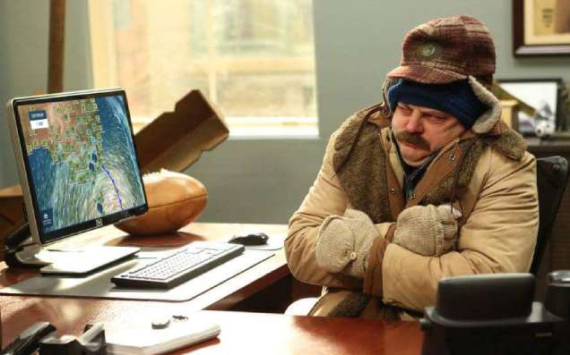
Dr Adam Morgan – weather knower – says that rain, wind, snow and thunderstorms are coming through with the big cold front. Looking at the radar it literally looks like Mr Freeze is huffing his ice-cold breath over the right-hand side of the country.
Severe Weather Update: widespread cold outbreak across southern Australia
Video current at 1:00 pm AEST Tuesday 28 April 2020
Know your weather. Know your risk.
For the latest weather forecasts and warnings visit https://t.co/HcFFoWwk1o @SA_SES @vicSESnews @TasmaniaSES pic.twitter.com/jLWB5SJhB2— Bureau of Meteorology, Australia (@BOM_au) April 28, 2020
All you lucky Sydney folk will get the Big Chill cold snap on Saturday, right in time for the weekend, with top temperatures dropping down to around 16º and those in Brisbane might need to get the flannels out early this year with a weekend of low-to-mid 20s on the way.
Crank up the heater, it’s happening. Winter is coming.