One of the many marvels about travelling to big, bustling cities overseas is the marvel of navigating their public transport systems with sheer ease.
Thanks to integrating the information into Google Maps, getting from Point A to Point B is a dream in literally just about every major city on the planet.
Except freaking Melbourne.
Before now, figuring out how to get to an unfamiliar somewhere was a mess of navigating many different websites and services. You’d look up the location on maps, zoom in and scroll around until you found a nearby tram or train stop, Google that tram or train stop to try and figure out which train line or what number tram went there, attempted to wrestle with the PTV trip planner to figure out when you’d need to leave in order to get there on time, and then just cross your fingers and hope that a slight breeze hasn’t sent the entire network bung.
It was an absolute pain.
But not anymore!
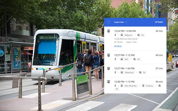
As of today, public transport information for the Victorian capital has officially been integrated into Google Maps, and it is an ABSOLUTE TREAT, I tell you.
The State Government made the public transport timetables available in a Google-friendly format just shy of a year ago, but it’s taken the cute dog pic search service this long to bring them into effect in maps.
Interestingly enough, the new system shines a convenient, easy-to-understand spotlight on just how precisely borked the network is, with suggested routes of tram/train/train/tram/bus/bus/tram now the norm.
The data also only relies on physical timetables, rather than real-time information, meaning TramTracker is still your absolute best mate.
But still, a step forward is a step forward. Get routing, pals!
Photo: John Eveson/Getty.


